Five Themes of Geography
Sierra Leone, offically called The Republic of Sierra Leone, is located located in Africa. Relatively speaking Sierra Leone is bordered by Guinea to the north, Liberia to the southeast and the Atlantic Ocean to the south and southwest. To be specific, Sierra Leone is between 7 and 10 degrees north and 10.5 and 13 degrees west. With a total of 27,653 square miles, this makes Sierra Leone about half the size of Illinois, which is kind of small. There is a population of about 5,245,695 where 1,051,000 live in the capital city of Freetown.
Sierra Leone has a tropical climate where from May to October there is a lot of percipiation and between November and April there isn't as much. Overall the average temperature is anywhere from 73 to 88 degrees Fahrenheit.
Sierra Leone itsself is divided into four disinct regions. One regionis the interior plateaux and mountains that rise in the east and northeast and formthe Tingi Hills and Loma Mountains. The second region is the interior low plains which consists of rolling lowlands that have swampy grasslands that are known as Bolilands. The third region is the coastal swamp lands that are located on a plain have many peninsulas and estuaries. Lastly, the fourth region known as the Sierra Leone Peninsula which is a mountainous area with a strip of flat land at the foothill of the mountain. Since the biggest part of the country is mountains and swamp the people living there have adapted to the conditions by building homes and buildings on the foothills where the land is flatter and easier to move things.
Sierra Leone's major exports include Bauxite, Cocoa, Diamonds, Iron Ore, and Palm Kernels, but they also export Coffee, Fish, Cassava, Ground Nuts, Palm Nuts and Timber. They mainly export these goods to countries such as the United Kingdom, Japan, Germany, Nigeria, China and the Netherlands. Their transportation mainly consists of cars and trucks along with boat and shipping transportation.
Sierra Leone Map
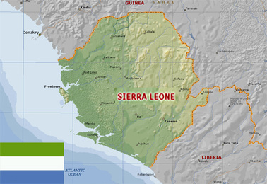
This Map shows a couple counties that border it and also the county's flag.
